Class 11 Geography Notes Chapter 4 Distribution of Oceans and Continents
Continents cover 29% of the surface of the earth and the remainder 71% is under oceanic waters.
Alfred Wegener—a German meteorologist put forth a comprehensive argument in the form of “the continental drift theory” in 1912. This was regarding the distribution of the oceans and the continents.
According to Wegener, all the continents formed a single continental mass and mega ocean surrounded the same. The super continent was named PANGAEA, which meant all earth. The mega-ocean was called PANTHALA5SA, meaning all water.
Wegener argued that, around 200 million years ago, the super continent, Pangaea, began to split. Pangaea first broke into two large continental masses as Laurasia and Gondwanaland forming the northern and southern components respectively. Subsequently, Laurasia and Gondwanaland continued to break into various smaller continents that exist today.
The radiometric dating methods developed in the recent period have facilitated correlating the rock formation from different continents across the vast ocean.
The ocean floor may be segmented into three major divisions based on the depth as well as the forms of relief. These divisions are continental margins, deep-sea basins and mid-ocean ridges.
Concept of sea floor spreading was proposed by Hess in 1981 who believed that new lava pushes out the plates from the mid-oceanic ridge
It was in 1967, McKenzie and Parker and also Morgan, independently collected the available ideas and came out with another concept termed Plate Tectonics.
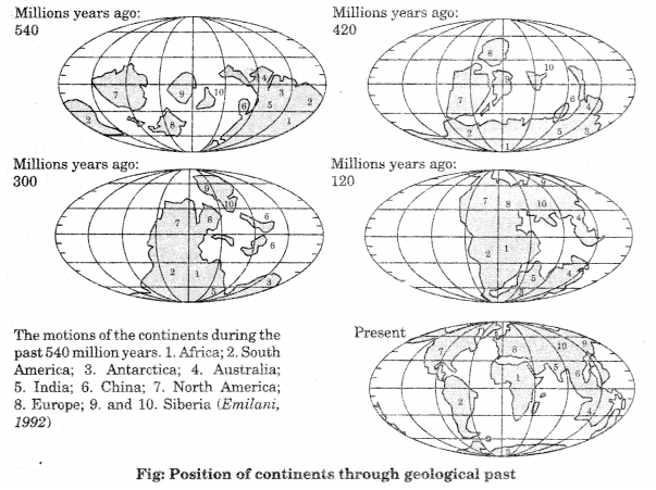
India is supposed to have started her northward journey about 200 million years ago at the time when Pangaea broke. India collided with Asia about 40-50 million years ago causing rapid uplift of the Himalayas.
The theory of plate tectonics proposes that the earth’s lithosphere is divided into seven major and some minor plates.
Class 11 Geography Notes Chapter 4 Important Terms:
- Convective flow: The heated material rises to the surface, spreads and begins to cool, and then sinks back into deeper depths. This cycle is repeated over and over to generate what scientists call a convection cell or convective flow.
- PANGAEA: The super continent was named PANGAEA, which meant all earth.
- PANTHALASSA: The mega-ocean was called PANTHALASSA, meaning all water.
- Rim of Fire: The rim of the Pacific is also called rim of fire due to the existence of active volcanoes in this area.
- Convergent Boundaries: Where the crust is destroyed as one plate dived under another, it is called convergent boundaries.
- Subduction Zone: The location where sinking of a plate occurs is called a subduction zone.
- Divergent Boundaries: Where new crust is generated as the plates pull away from each other, these are called divergent boundaries.
- Spreading Sites: The sites where the plates move away from each other are called spreading sites.
- Transform Boundaries: Where the crust is neither produced nor destroyed as the plates slide horizontally past each other.
- Tectonic plate: It is a massive, irregularly-shaped slab of solid rock, generally composed of both continental and oceanic lithosphere. Plates move horizontally over the asthenosphere as rigid units. .
- Tillite: It is the sedimentary rock formed out of deposits of glaciers.
- Sea Floor Spreading: The deep trenches have deep-seated earthquake occurrences while in the mid- oceanic ridge areas, the quake foci have shallow depths. These facts and a detailed analysis of magnetic properties of the rocks on either sides of the mid-oceanic ridge led Hess in 1961 to propose his hypothesis. It was called the “sea floor spreading”.
Mohd. Sharif Qualification: B.Tech (Mechanical Engineering) [Founder of Wisdom Academy] [Aim Foundation & Free-Education.In] [Engineer By Profession | Teacher By Choice] [Blogger, YouTube Creator]