Chapter 4 Climate Questions NCERT Solutions for Class 9 SST Geography
Question-1
What are the controls affecting the climate of India?
Solution:
There are six major controls of the climate of any place. They are:
- Latitude
- Altitude
- Pressure and wind system
- Distance from the sea (continentality)
- Ocean currents
- Relief features
Question-2
Why does India have a monsoon type of climate?
Solution:
The monsoon type of climate is characterised by a distinct seasonal pattern. The weather conditions greatly change from one season to the other. These changes are particularly noticeable in the interior parts of the country. The coastal areas do not experience much variation in temperature though there is variation in rainfall patterns. Four main seasons can be identified in India – the cold-weather season, the hot weather season, the advancing monsoon, and the retreating monsoon with some regional variations.
Question-3
Which winds account for rainfall along the Malabar Coast?
Solution:
Surface winds account for rainfall along the Malabar coast.
Question-4
What are Jet streams and how do they affect the climate of India?
Solution:
Jet streams are a narrow belt of high altitude (above 12,000 m) westerly winds in the troposphere. Their speed varies from about 110 km/h in summer to about 184 km/h in winter. A number of separate jet streams have been identified. The most constant is the mid-latitude and the subtropical jet stream.
Over India, these jet streams blow south of the Himalayas, all through the year except in summer. The western cyclonic disturbances experienced in the north and northwestern parts of the country are brought in by this westerly flow. In summer, the subtropical westerly jet stream moves north of the Himalayas with the apparent movement of the sun. An easterly jet stream, called the tropical easterly jet stream blows over peninsular India, approximately over 14°N during the summer months.
Question-5
Define monsoons. What do you understand by “breaks” in monsoon?
Solution:
The seasonal reversal in wind direction during a yeat is called the monsoon. Monsoon tends to have ‘breaks’ in rainfall; which means that there are wet and dry spells in between The monsoon rains take place only for a few days at a time and then come to the rainless intervals.
Question-6
Why is the monsoon considered a unifying bond?
Solution:
Despite great moderating influences on the climate of India, there are great variations in the temperature conditions. Nevertheless, the unifying influence of the monsoon on the Indian subcontinent is quite perceptible. The seasonal alteration of the wind systems and the associated weather conditions provide a rhythmic cycle of seasons.
Question-7
Why does the rainfall decrease from the east to the west in Northern India?
Solution:
The western coast and northeastern India receive over about 400 cm of rainfall annually. However, it is less than 60 cm in western Rajasthan and adjoining parts of Gujarat, Haryana, and Punjab. Rainfall is equally low in the interior of the Deccan plateau, and east of the Sahyadris. The third area of low precipitation is around Leh in Jammu and Kashmir. The rest of the country receives moderate rainfall.
Snowfall is restricted to the Himalayan region. Owing to the nature of monsoons, the annual rainfall is highly variable from year to year. Variability is high in the regions of low rainfall such as parts of Rajasthan, Gujarat and the leeward side of the Western Ghats. As such, while areas of high rainfall are liable to be affected by floods, areas of low rainfall are drought-prone.
Question-8
Give reasons as to why.
(i) The bulk of rainfall in India is concentrated over a few months.
(ii) The Tamil Nadu coast receives winter rainfall.
(iii) The delta region of the eastern coast is frequently struck by cyclones.
(iv) Parts of Rajasthan, Gujarat, and the leeward side of the Western Ghats are drought-prone.
Solution:
(i) The bulk of rainfall in India is concentrated over a few months
The inflow of the south-west monsoon into India brings about a total change in the weather. Early in the season, the windward side of the Western Ghats receives very heavy rainfall, more than 250 cm. The Deccan Plateau and parts of Madhya Pradesh also receive some amount of rain in spite of lying in the rain shadow area. The maximum rainfall of this season is received in the north-eastern part of the country. Mawsynram in the southern ranges of the Khasi Hills receives the highest average rainfall in the world. Rainfall in the Ganga valley decreases from the east to the west. Rajasthan and parts of Gujarat get scanty rainfall.
(ii) The Tamil Nadu coast receives winter rainfall
A characteristic feature of the cold weather season over the northern plains is the inflow of cyclonic disturbances from the west and the northwest. These low-pressure systems, originate over the Mediterranean Sea and western Asia and move into India, along with the westerly flow. They cause the much-needed winter rains over the plains and snowfall in the mountains. Although the total amount of winter rainfall locally known as ‘mahawat’ is small, they are of immense importance for the cultivation of ‘rabi’ crops. The peninsular region does not have a well-defined cold season. There is hardly any noticeable seasonal change in temperature patterns during winters due to the moderating influence of the sea.
(iii) The delta region of the eastern coast is frequently struck by cyclones
The low-pressure conditions, over northwestern India, get transferred to the Bay of Bengal by early November. This shift is associated with the occurrence of cyclonic depressions, which originate over the Andaman Sea. These cyclones generally cross the eastern coasts of India cause heavy and widespread rain. These tropical cyclones are often very destructive. The thickly populated deltas of the Godavari, the Krishna and the Kaveri are frequently struck by cyclones, which cause great damage to life and property. Sometimes, these cyclones arrive at the coasts of Orissa, West Bengal and Bangladesh.
(iv) Parts of Rajasthan, Gujarat and the leeward side of the Western Ghats are drought-prone
Owing to the nature of monsoons, the annual rainfall is highly variable from year to year. Variability is high in the regions of low rainfall such as parts of Rajasthan, Gujarat and the leeward side of the Western Ghats. As such, while areas of high rainfall are liable to be affected by floods, areas of low rainfall are drought-prone.
Question-9
Describe the regional variations in the climatic conditions of India with the help of suitable examples.
Solution:
Despite an overall unity in the general pattern, there are perceptible regional variations in climatic conditions within the country. The two important elements, which cause these variations, are – temperature and precipitation.
For example, in summer, the mercury occasionally touches 50°C in some parts of the Rajasthan desert, whereas it may be around 20°C in Pahalgam in Jammu and Kashmir. On a winter night, the temperature at Drass in Jammu and Kashmir may be as low as minus 45°C. Tiruvananthapuram, on the other hand, may have a temperature of 20°C.
Question-10
Discuss the mechanism of monsoons.
Solution:
To understand the mechanism of the monsoons, the following facts are important.
- The differential heating and cooling of land and water create a low pressure on the landmass of India while the seas around experience comparatively high pressure.
- The shift of the position of Inter-Tropical Convergence Zone (ITCZ) in summer, over the Ganga plain (this is the equatorial trough normally positioned about 5°N of the equator – also known as the monsoon trough during the monsoon season).
- The presence of the high-pressure area, east of Madagascar, approximately 20°S over the Indian Ocean. The intensity and position of this high-pressure area affect the Indian Monsoon.
- The Tibetan plateau gets intensely heated during summer, which results in strong vertical air currents and the formation of high pressure over the plateau at about 9 km above sea level.
- The movement of the westerly jet stream to the north of the Himalayas and the presence of the tropical easterly jet stream over the Indian peninsula during summer.
Question-11
Give an account of weather conditions and characteristics of the cold season.
Solution:
The weather conditions greatly change from one season to the other. These changes are particularly noticeable in the interior parts of the country. The coastal areas do not experience much variation in temperature though there is variation in rainfall patterns. The cold weather season begins from mid- November in northern India and stays till February. December and January are the coldest months in the northern part of India. The temperature decreases from the south to the north. The average temperature of Chennai, on the eastern coast, is between 24° – 25° Celsius, while in the northern plains, it ranges between 10° – 15° Celsius. Days are warm and nights are cold. Frost is common in the north and the higher slopes of the Himalayas experience snowfall.
Question-12
Give the characteristics and effects of the monsoon rainfall in India.
Solution:
The Monsoon, unlike the trades, are not steady winds but are pulsating in nature, affected by different atmospheric conditions encountered by it, on its way over the warm tropical seas. The duration of the monsoon is between 100- 120 days from early June to mid-September. Around the time of its arrival, the normal rainfall increases suddenly and continues constantly for several days. This is known as the ‘burst’ of the monsoon and can be distinguished from the pre-monsoon showers.
The monsoon arrives at the southern tip of the Indian peninsula generally by the first week of June. Subsequently, it divides into two – the Arabian Sea branch and the Bay of Bengal branch. The Arabian Sea branch reaches Mumbai about ten days later on approximately the 10th of June. This is a fairly rapid advance.
The Bay of Bengal branch also advances rapidly and arrives in Assam in the first week of June. The lofty mountains cause the monsoon winds to deflect towards the west over the Ganga plains. By mid-June, the Arabian Sea branch of the monsoon arrives over Saurashtra-Kuchchh and the central part of the country.
The Arabian Sea and the Bay of Bengal branches of the monsoon merge over the northwestern part of the Ganga plains. Delhi generally receives the monsoon showers from the Bay of Bengal branch by the end of June (tentative date is 29th of June). By the first week of July, western Uttar Pradesh, Punjab, Haryana and eastern Rajasthan experience the monsoon.
By mid-July, the monsoon reaches Himachal Pradesh and the rest of the country. Withdrawal or the retreat of the monsoon is a more gradual process. The withdrawal of the monsoon begins in the northwestern states of India by early September. By mid-October, it withdraws completely from the northern half of the peninsula. The withdrawal from the southern half of the peninsula is fairly rapid. By early December, the monsoon has withdrawn from the rest of the country.
The islands receive the very first monsoon showers, progressively from south to north, from the first week of April to the first week of May. The withdrawal takes place progressively from north to south from the first week of December to the first week of January. By this time the rest of the country is already under the influence of the winter monsoon.
Climate Class 9 Important Questions Very Short Answer Type Questions
Question 1.
What is climate? [CBSE 2014]
Answer:
The climate refers to the sum total of weather conditions and variations over a large area for a long period of time.
Question 2.
What is weather?
Answer:
‘Weather’ refers to the state of the atmosphere over an area at any point of time.
Question 3.
Name the. elements of weather and climate.
Answer:
Temperature, atmospheric pressure, wind, humidity and precipitation.
Question 4.
What does ‘monsoon’ imply? [CBSE 2015]
Answer:
The word, ‘monsoon’ comes from the Arabic word’ mausim’ which means season. It implies a seasonal reversal in the wind direction throughout the year.
Question 5.
Which are the rainest months of India?
Answer:
June to September
Question 6.
Name the month in which the withdrawl of monsoon begins.
Answer:
September
Question 7.
Which region of India receives most of its rainfall in winter?
Answer:
Tamil Nadu coast.
Question 8.
Name the two branches of the monsoon.
Answer:
- The Arabian Sea branch.
- The Bay of Bengal branch.
Question 9.
What is burst of monsoon? [CBSE 2015]
Answer:
Around the time of its arrival, the normal rainfall increases suddenly and continues constantly for several days. This is known as the ‘burst’ of the monsoon.
Question 10.
What me the ‘retreating monsoons’? [CBSE 2014]
Answer:
During the months of October and November, the temperature in the Northern plains begins to decrease, and because of low temperature, the pressure starts rising and the low pressure is no longer strong enough to attract the monsoon winds. This results in the retreat of the monsoon.
Question 11.
With reference to the ‘Cold weather season in India, answer the following questions.
(i) What is its time period?
(ii) Name the winds which prevail over the country during this season.
Answer:
(i) Mid November to February.
(ii) North-East trade winds.
Question 12.
Name the winds from which the Tamil Nadu coast receive winter rainfall?
Answer.
North-East monsoons which reach there after passing over the Bay of Bengal, and picking moisture from there. .
Question 13.
Name two coldest areas in India.
Answer:
Dras and Kargil (Temperature – 40°C)
Question 14.
Which is the wettest place in India?
Answer:
Mawsynram in the southern ranges of the Khasi hills.
Question 15.
What is a jet stream?
Answer:
A jet stream is a fast blowing wind blowing in a narrow zone in the upper atmosphere.
Question 16.
‘The peninsular region does not have a well defined cold season.’ Give reason.
Answer:
Due to the moderating influence of the sea, the peninsular region does not have a well defined cold season.
Question 17.
Name two states where mango showers are common. [CBSE 2000(B)]
Answer:
Kerala and Karnataka.
Question 18.
Name two states on the eastern coast which are frequently struck by the tropical cyclones.
Answer:
Andhra Pradesh and Tamil Nadu.
Question 19.
What is meant by breaking of monsoon or burst of the monsoon?
Answer:
The rain bearing monsoons are extremely strong and violent. Their approach is accompanied by thunder and lightning. This is known as the Wreaking of monsoon.
Question 20.
What is the name given to the climate of India?
Answer:
The Monsoon climate.
Question 21.
What is loo?
Answer:
It is a local wind which is hot and dry.
Question 22.
Name the wind which prevails over India in winter season.[CBSE 2013]
Answer:
North-East trade winds.
Question 23.
Two stations with most equable climate.
Answer:
Mumbai and Chennai.
Question 24.
Two stations with most extreme climate.
Answer:
Leh and Jodhpur.
Question 25.
Name any two regions which receive over 400 cm of rainfall.
Answer:
The Western coast and the North-eastern India receive over 400 cm of rainfall.
Question 26.
Name two stations influenced by the retreating and the North-East monsoons.
Answer:
Chennai and Bengaluru.
Question 27.
Two stations receiving winter showers from the western disturbances.
Answer:
Amritsar and Delhi.
Question 28.
State two chief characteristics of the Western Disturbances? [CBSE1995,2013]
Answer:
- These originate over the east Mediterranean sea.
- These cause rain in North India.
Climate Class 9 Important Questions Short Answer Type Questions
Question 1.
“ Despite an overall unity in the gen¬eral pattern of climate of India,there are perceptible regional variations in climatic conditions within the country.” Justify.
Or
“India has diverse climatic conditions”Support this statement by giving examples, each of tempera¬ture and precipitation.
Answer:
- The mercury occasionally touches 50°C in the western deserts, and it drops down to as low as -45°C in winter around Leh.
- The annual precipitation is less than 10 cm in the north-west Himalayas and the western desert. It exceeds 400 cm in Meghalaya.
- Most parts of the country receive rainfall from June to September, but some parts like the Tamil Nadu coast get most of its rain during October and November.
Question 2.
Explain the factors affecting India’s climate. [CBSE 2015]
Answer:
- Latitude : The Tropic of Cancer passes through the middle of the country from the Rann of Kuchchh in the west to Mizoram in the east. Almost half of the country, lying south of the Tropic of Cancer, belongs to the tropical area. All the remaining area, north of the Tropic, lies in the sub-tropic. Therefore, India’s climate has characteristics of tropical as well as subtropical climates.
- Altitude: India has mountains to the north which have an average height of about 6,000 metres. India also has a.vast coastal area where the maximum elevation i% about 30 metres. The Himalayas prevent the cold winds from Central AsiafrQm entering the subcontinent. It is because of these mountains that this subcontinent experiences comparatively milder winters as compared to central Asia.
- Pressure and Winds: The pressure and wind conditions over India are unique. During winter, there is a high-pressure area north of the Himalayas. Cold dry winds blow from this region to the low-pressure areas over the oceans to the south. In summer, a low-pressure area develops over interior Asia as well as over northwestern India. This causes a complete reversal of the direction of winds during summer. Air moves from the high-pressure area over the southern Indian Ocean, in a south¬easterly direction, crosses the equator, and turns right towards the low-pressure areas over the Indian subcontinent. These are known as the Southwest Monsoon winds. These winds blow over the warm oceans, gather moisture and bring widespread rainfall over the mainland of India.
Question 3.
Mention any three characteristics of the Monsoon’.[CBSE 2011,12,14 ]
Answer:
- The Monsoons are pulsating in nature.
- These are affected by different atmospheric conditions prevailing in the region.
- The duration of the monsoon is between 100 – 120 days.
Question 4.
What is “October Heat”?
Answer:
The months of October-November form a period of transition from a hot rainy season to dry winter conditions. The retreat of monsoons is marked by clear skies, and rise in temperature. The land is still moist. Owing to the condition of high temperature and humidity, the weather becomes rather oppressive. This is commonly known as ‘October Heat’.
Question 5.
Explain development of Monsoon Trough and its influence over rainfall distribution. [CBSE 2014]
Answer:
- It is a region of low atmospheric pressure which develops because of excessive heat.
- It brings a remarkable change in rainfall pattern.
- It is responsible for diy and wet spells of monsoon.
Questions.6.
Give reasons as to why:
(i) Seasonal reversal of wind direction takes place over the Indian subcontinent.
(ii) The bulk rainfall in India is concentrated over a few months.
(iii) The Tamil Nadu coast receives winter rainfall.
(iv) The delta region of the eastern coast is frequently struck by cyclones.
(v) Parts of Rajasthan, Gujarat and the leeward side of the Western Ghats are drought prone.
Answer:
(i)
- During winter, there is a high pressure area over north of the . Himalayas. Whereas, there is low pressure area over the ocean to the south. So cold and dry winds blow from the Himalayan region towards the ocean.
- During summer, a low pressure area develops over the interior , Asia as well %is over the Northwestern India. This causes a complete reversal of the direction of winds during summer.
(ii)
- Most parts of India receive rainfall from the south-west monsoons which blow in India only between June to September.
- Only the eastern coast of India receives some rainfall from the North-East trade winds during the cold weather season.
- It is because Tamil Nadu gets rain from the north-east monsoons which reach there after passing over the Bay of Bengal, after picking moisture from there.
(iv)
- In the mid-October, the mercury
begins to fall at a rapid speed in Northern India. - The low pressure conditions of the North shifts to the Bay of Bengal by November. This shift causes cyclonic depressions in the Andaman Sea.
- These cyclonic depressions give rise to tropical cyclones which cause heavy and widespread rains in the deltas of the Godavari, the Krishna and the Kaveri.
(v)
- Rajasthan does not receive much rain because the Aravalli Range which lies parallel to the direction of the winds and hence condensation does not occur.
- Gujrat receives less rainfall because there are no hills and mountain ranges.
The leeward side of the Western Ghats receives less rainfall because when air descends, it gets warmed up. Due to its rising temperature, the relative, humidity of air decreases, and the air turns from a saturated state to an unsaturated state. Due to his fact, no rainfall occurs on the leeward side.
Climate Class 9 Important Questions Long Answer Type Questions
Questions.1.
Compare the hot weather season of India with that of cold weather season.
Answer:

Questions.2.
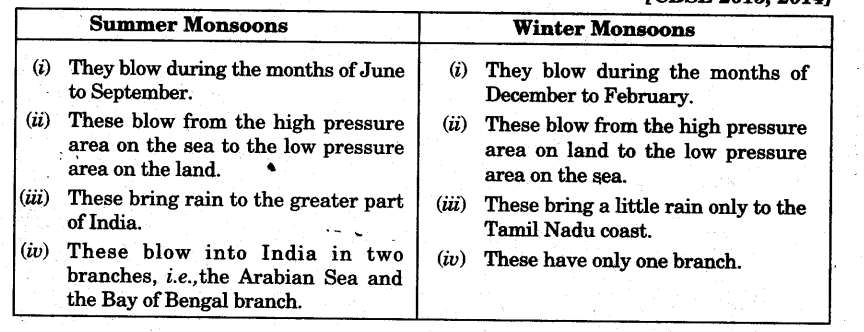
How will you differentiate between the summer and winter monsoons?
Or
Differentiate between South-West and North-East trade winds.
Answer:
Climate Class 9 Important Questions Higher Order Thinking Skills (Huts) Questions
Questions. 1.
Give reason for the following:
(i) Thiruvananthapuram has the year equable climate.
(ii) Delhi has extreme climate.
(iii) The Tamil Nadu coast receives winter rainfall.
(iv) Leh has moderate precipitation almost through-out the year.
(v) The delta region of the eastern coast is frequently struck by cyclones.
Answer:
(i) It has equable climate due to proximity to sea. Sea has moderating influence over its climate.
(ii) Because Delhi is far away from sea. As the distance from the sea increases,its moderating influence decreases.
(iii) Tamil Nadu receives rainfall from North-east trade winds.
(iv) Leh is at a very high altitude. During the cold weather season, the ‘Western Disturbances’ contribute to heavy snowfall in this region. Both south-west and south¬east monsoons also cause precipitation in this part.
(ii) (a) In the mid October, the mercury begins to fall at a rapid speed in Northern India.
(b)The low pressure conditions of the North shifts to the Bay of the Godavari, the Krishna and the Kaveri.
Questions.2.
Carefully study the given rainfall and temperature graphs and answer the following of questions:
(i) Which station receives more rainfall?
Answer:
Shillong.
(ii) Which is the rainiest month of Shillong?
Answer:
June
(iii) Which is the coldest month in Leh?
Answer:
January
(iv) Compare the climatic conditions of both the stations with reference to rainfall and temperature.
Answer:
- Leh receives very low rainfall whereas Shillong receives very high rainfall.
- Temperature in Leh remains very low throughout the year whereas temperature in Shillong remains between 10°C to 20°C.
Bengal by November. This shift causes cyclonic depressions in the Andaman Sea. - These cyclonic depressions give rise to tropical cyclones which cause heavy and widespread rains in the deltas
Questions.3.
Study the climatic data given below and answer the questions that follow: [CBSE2014]
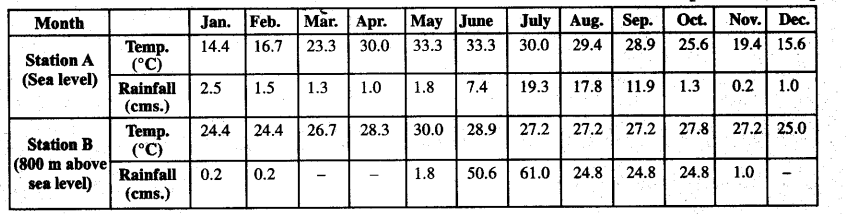
(i) Calculate the annual range of temperature of Station A. Why is the range of . temperature very low?
(ii) Which of the two Stations has the lower temperature? Why?
(iii) Calculate the annual rainfall of Station B.
Answer:
(i) 5.6 Because the station is near the sea.
(ii) Station B. Because of high altitude.
(iii) Annual rainfall of station B is 31.8 cm.
Questions.4.
Given below is the climate data – mean monthly temperatures and mean monthly rainfall for stations A, B and C from India. Study the data carefully and answer the following questions:
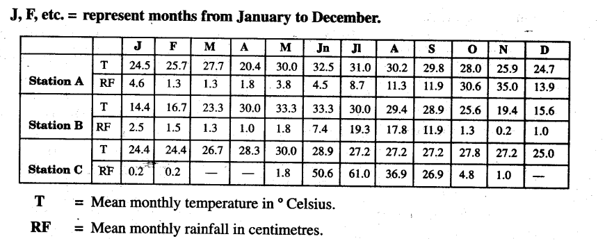
(i) What is the annual range of temperature in Station A?
Answer:
The annual range of temperature in Station A (32.5°C — 24.5°C) = 8°C
(ii) What is the annual rainfall experienced by the Station A?
Answer.
4.6+1.3+ 1.3 = 128.7 cm.
(iii) Name the wettest month in Station A.
Answer.
November.
(iv) Calculate the annual rainfall of Station C.
Answer.
The annual rainfall of Station C is 183.4 cm. (0.2 + 0.2 + 1.8 + 50.6..)
Climate Class 9 Important Questions Value Based Questions
Questions.1.
Which moral values the monsoon teaches us? Mention any two.
Answer:
- Monsoon acts as a unifying bond.
- Monsoon are responsible for unity in diversity.
Questions.2.
Why the people of India eagerly awaits the arrival of the monsoon?
Answer:
These monsoon winds binds the whole country by providing water to set the agricultural activities in motion.
Questions.3.
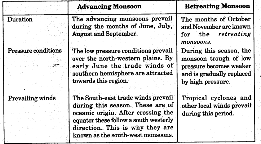
Compare he retreating monsoon with advancing monsoon.
Or
Mention any three features of retreating monsoon.
Or
Mention any four features of advancing monsoon.
Answer:
Questions.2.
“Monsoon acts as a unifying bond”. Explain. [CBSE March 2013,15]
Answer:
- The seasonal alteration of the wind systems and the associated weather conditions provide a rhythmic cycle of seasons. Even the uncertainties of rain and uneven distribution are very much typical of the monsoons.
- The Indian landscape, its animal and plant life, its entire agricultural calendar arid the life of the people, including their festivities, revolve around this phenomenon. Year after year, people of India from north to south and from east to west, eagerly await the arrival of the monsoon.
- These monsoon winds bind the whole country by providing water to set the agricultural activities in motion. The river valleys which carry this water also unite as a single river valley unit.